Search
Now showing items 1-5 of 5
GIS-based modeling in greater Mymensingh for sustainable aquaculture development and management: final report
Type: Report
The purpose of this study was to identify the potential site for sustainable aquaculture development in Mymensingh district using GIS as a tool.
Delineating recommendation domains for small-scale freshwater aquaculture: deploying GIS for decision support
Type: Book Chapter
This paper highlights Geographical Information System (GIS) applications in an on-going, three-year project to develop spatial decision-support tools for identifying recommendation domains (places and sets of conditions) ...
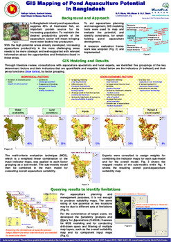
GIS mapping of pond aquaculture potential in Bangladesh
Type: Brief
In Bangladesh inland pond aquaculture supplies 45% of freshwater fish, an important protein source for its increasing population. To maintain the desired productivity growth of the aquaculture sector will mean bringing ...
Landscape level characterization of seasonal floodplains under community based aquaculture: illustrating a case of the Ganges and the Mekong Delta
Type: Working Paper
The project 'Community-based Fish Culture in Seasonal Floodplains' (henceforward the community-based fish culture project), CGIAR Challenge Program on Water and Food, aims to enhance fish production in seasonal floodplains ...
Explaining climate variability vis-a-vis spatio-temporal interactions in Bangladeshi Exclusive Economic Zone (BEEZ)
Type: Journal Article
We present an application of time series remote sensing data and climatological information for improved understanding of complexity in the Bangladeshi Exclusive Economic Zone (BEEZ). Three seasonal slots from the annual ...